Campaign map - help to improve it

Users who are viewing this thread

Greetings,

Our friend Hunterwolf had volountier to help us out and fix and improve and optimize our campaign map.

Some parts of it surely is laking - like Eastern Europe have no rivers. So if any of you have any ideas on how to improve the map, post your screenshots with the missing geographical items(rivers, mountains, perhaps even woods). Don't be shy on suggestions, but be aware, that only the most important geographical items will be added.

Thanks for your help!  :eek:
 
STOP!  :mrgreen:

Some time ago I suggested that fiefs should actually control the sorrounding areas. Before you start reworking the campaign map I would like to remind you of it, as I think it could improve gameplay and reality a lot.

Just for refreshing purposes:

My idea was that every fief has a "hidden" second garrison, which is a certain percentage of the actual garrison. Whenever an enemy party is spotted or one of the attached villages reports visual on an enemy, this "hidden" garrison leaves the fief and goes after the enemy, up to a certain distance, of course. The garrison will not leave, if the enemy force is stronger, of course. It's like some kind of patrol which only leaves when enemies are spotted and comes back as soon as they are out of range.

Next to this spending some time close to an enemy fief will have a few men of your party knocked out (or even killed)? every few hours, to represent the enemies sallying out and attacking your supply lines and the like. (Which was the real world reason why you couldn't just move past an enemy castle and ignore it)

That way enemy territory becomes really ugly to cross. The point of a seperate "hidden" garrison is simply to prevent the player of finding the enemy garrison of a large city outside the walls, slaughtering a caravan, attacking them on the open field, beating them and taking the city easily afterwards.

You can also implement parties of one or two or a few more scouts, which roam the enemy lands. Whenever they see and enemy they will of course run away, because they are only two men, and then a script triggers which starts a counter. After a few hours the surrounding fiefs spawn their hidden garrison coming to the aid of the scouts. If the scouts get killed before the time runs out, nothing happens. This represents being discovered by enemy scouts and having to catch and kill them before they can warn the enemies. It's pure reality  :mrgreen:

If the hidden garrison gets destroyed in the field somehow, it slowly starts regenerating in the fief.

But I fear the campaign AI would need to be rewritten to only attack neighbouring fiefs, instead of random ones, or the feature won't work properly.

But if you decide to use that feature, it would also make sense to change the map in a way that it has more bottlenecks to support this feature, so that you need to move past enemy fiefs, representing the advantageous locations they used to be built at.

And as you have the bottlenecks near the fiefs, you can implement another small idea of me, where every caravan which is passing the control area of a fief has to pay a little toll. That way it becomes really rewarding to conquer a fief close to important trade routes.

Sorry if I am derailing the topic a bit, but I think it's worth a thought.  :wink:  :razz:
 
I will quickly throw my two cents into this

idea was that every fief has a "hidden" second garrison,
They would need to lower the amount of garrisoned troops in the castle then, as trying to take a castle with a 2000+ army is not a walk in the woods, (well not on the hardest difficulty) We lost 1000 men and 800 or so to wounding, afterwards what was left of the gaelic armies, simply ran around capturing the lords laden with the wounded. So to first fight off a essentially small(ish) army, and then to attack a castle wouldn't work unless you half the castle or leave 2/3 in the castle and have the other 1/3 garrisoned in the hidden place.

Next to this spending some time close to an enemy fief will have a few men of your party knocked out (or even killed)? every few hours, to represent the enemies sallying out and attacking your supply lines and the like. (Which was the real world reason why you couldn't just move past an enemy castle and ignore it)
I would disagree with this as your party sizes are so small comparison to real life, my average military size is about 70 - 80 so having 5% of my army killed or knocked out because im close to an enemy castle is a no no for me, Perhaps if there was a way to increase all the armies to life size then yes that would be a good idea.

you need to catch and kill them before they can warn the sorrounding fiefs.
Issue with this of course the view distance for parties in warband is so high that it would be virtually impossible to get through without being seen, and also a 2 man unit can and would easily outrun an entire army! Think of it when chasing people left over from battles, or those pesky 20 man "armies" you see roaming around, you can never catch the blighters.

And as you have the bottlenecks near the fiefs, you can implement another small idea of me, where every caravan which is passing the control area of a fief has to pay a little toll.

I like the toll idea, but as for the bottlenecks eeeesh :L  I personally like being able to run around and avoid certain areas, rather than being forced to pass a town, i can simply go around it, especially if im going to loose %5 of my army, i would rather just give that town/castle a wide birth thanks! But like i said, the toll area would be cool, the more safer the surrounding area, I.E clearing the bandits which roam with gay abandon, would increase the amount of caravans thus giving you more revenue, so that's a jolly good idea.

As for the first bit about the hidden second garrison, you should be able to choose which units go into it, as i would rather leave the spearmen, peasants and of course archers in the safety of a castle, and have a mix of Cav, inf, and archers in the second garrison.

At the end of the day this is just my opinion on the topic. So take what you want from it, leave the rest. Its nice to be creative :smile:
 
I've been wondering, you can not read or just can not take Writing.

I can read and write, Simply pointing out flaws that would need tweaking if they were ever taken on, anyhow i have several questions before i post any suggestions,

1) Is the current thickness of rivers the smallest they can be, as the one running through england is practically a sea :razz:
2) Does this include moving towns? as Gloucester is currently situated in the middle of england rather than beneath Hereford.
3) Are the two above counted as "important geographical items"?

 
At me now night. Tomorrow I will write instructions that should be considered when selecting objects and that you should pay attention and answer all your questions.
 
He said that it's night by the time he's writing this and tomorrow (i.e. today) he'll write some instructions on which objects are to be considered important etc.
 
Just as i said in the general suggestions thread:
It'd be nice if you'd add Dniester and Prut
And the Dniper river near kiev was very important at that time too
And speaking of Kiev,is it me or is kiev in-game a bit lower than its original location on the map?

2012-08-15_00001.jpg

russian_river_map.gif
 
The Neman and the West Dvina/Daugava Rivers please.

I also can make the map with the biggest medieval forest massifs in Eastern Europe if you are interested as I have some materials about it.
 
kuauik said:
guys ,this is not a suggestion thread,its a thread where anyone can help with map editing

"So if any of you have any ideas on how to improve the map, post your screenshots with the missing geographical items(rivers, mountains, perhaps even woods)"
Disregard that
 
Ireland, where I live, is a bit messed up. I have a medical appointment tomorrow, but once that is over I might crudely 'shop in more accurate locations. Donegal town should be where Carrickabraghy is located. Carrickabraghey castle is on the Inishowen Peninsula, basically move it to the right somewhat. I will post an image tomorrow. A few other towns are a bit off in their locations. Limerick needs to shift left, Wexford castle towards the bottom right. Shannon river at least should be included, as a fairly important castle and town Rindoon was on a peninsula on the Shannon/Lough Ree, and was a sort of boundary with the O'Connor kingdom of Connacht.
 
Here's some of what I noticed:

As well as the Dnieper and the Volga, you could add Ladoga and Onega, if you want to make the border between Sweden and Novgorod clearer.

A small line of sea separating Anglesey from mainland Wales would look more lifelike. Same goes for Fehmarn and Rügen.

In the med, Malta could be added and the Nile delta (faded green possibly?) and floods (small area of green just next to the river) could be shown, rather than all desert.

In Northern Europe, Kalmar should be moved a bit north of where it is now so that it doesn't lie in the province of Blekinge and Denmark lacks the Limfjord which at this time would be blocked in the West by the sand (according to, in their time, Sven Aggesen and Saxo Grammaticus). Also, if you want to be generous, adding the Frisian islands, Öland and giving Sweden more trees couldn't hurt.

limfjorden.jpg


mb12t.jpg

Bohemia could do with a semi-lowlying mountain range

bohemia.jpg


mb13k.jpg

And finally, if you want, you could fix Istria and add some Dalmatian islands. Istria should be the only peninsular and Pula should be correctly placed on it.

Croatia_topo.jpg


mb14l.jpg

Well, those were the things most noticable to me anyway. Good luck in improving the map.
 
I ask forgiveness for absence some technical problems were. I will try to answer you all questions.
I will revise all your offers, and I will answer that it will be possible to add that isn't present. Concerning bridges, most likely it will be more convenient to make fords instead of bridges, in the majority of places


Additionally, to avoid creating new topic, I suggest to present your proposals on diefferent settlements.


First thing that needs to be considered are empty spaces on map - we will not add settlements in those places where there is a lack of them. Be advised that to add new settlement on empty space it is usually easier to take old one from heavily populated area and place it in an empty one on the map. You may advice changes on map if you think that there are historiacl inaccuracies, but please without fanatism - no need to move settlements 1 cm in any direction, as global map doesn't have exact realistic proportions.  Your suggestions must be argumented with references to information sources (language doesn't matter). Be advised, that location's names may be reflected in different languages, and you must consider this when making proposal. E.g. search for authentic name is on your concious. Settlements must have names that they had on the moment of game's start (don't forget that many towns had one name in 1230, but had it changed by 1257, so check the info that is relevant to the mod's start time. Also remember that in may sources there are stated different name sof the same settlement - so try to list them all and we will decide which one to use during constructive dialogue. Also consider different names of settlements that are ruled by one or another nation or country (in this case we are interested in the name relevant to the settlement's owning faction). Especially consider the size and importance of the settlement. If there are more important ones nearby the ones that are already in the mod, it is better to state them, as it is better for global map to have only the biggest and most important cities. Also don't forget that we are not writing history book, but making a  mod. So don't hussle over towns becoming villages (in the mod smaller towns are made villages for gameplay mechanics). All suggestions should be made in accordance with above-mentioned points and with regard to gameplay perspective. History can be put aside when one big and important city is situated in ver close proximity to another big and important one. reference to historical maps or chrnicals with details of their locations  is a must when you make suggestions.


Reworking the global map.
mbwarband20120920103341.png
On the screenshot of global map one should paint changes he would like to see. But be advised that there is no point in painting roads since creating them is VERY difficult procedure. What needs to be done: lakes, rivers, hills, mountains, forests (in limited quantities). If there are inaccuracies that are too great, you can point them out. Painting should be done in color different from the one present on global map screenshot. Also think about how these changes will affect the game. It is also advised to work with one region, and not jump from one to another. Add only biggest geographical objects, and by biggest I mean the size, not importance, as, alas, importance has no role in this case. Again, don’t be too fanatical about it, I can’t tell you exactly which quantity is good or bad, just use common logic and think about the possibility to play the game normally.
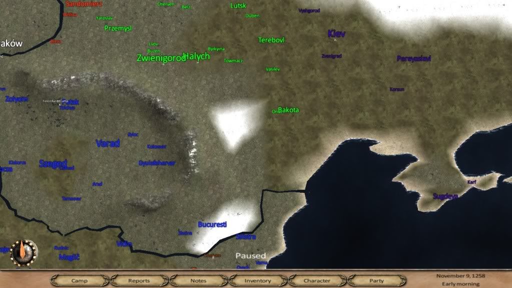
Here is an example of how a post should look like:
Try to draw schematically, as exact landscape is impossible to reflect.
On the screenshot are drawn a river and a like in violet color, they are moved a little, and in green color are new geographical locations.
It is also needed to write the names of this places on map.
You should state the info about the place and your arguments as of why you chose it.
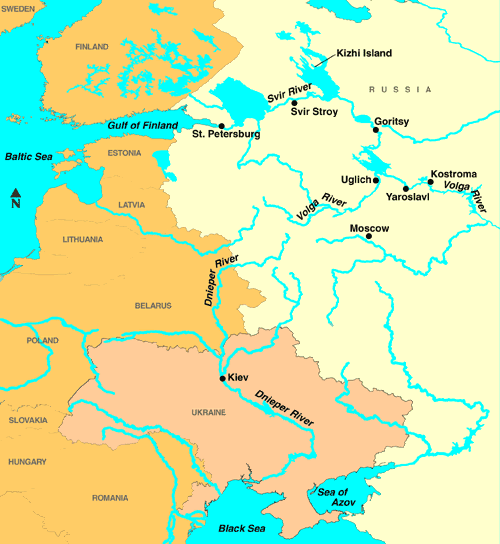
It would be great if you also added the map (at least from 13-th century) of this region with settlements on it.
Web-links to references with settlement’s descriptions would also be great.

 
I would really like to see an update in the Slovakian - Bohemian region.


The city of Pozsony needs to be moved more westwards, current place doesn't fit.
The brown circle resembles an empty unused space in the Bohemian region. Some forests or something similar could enlighten the place.

The spray tag is the river Váh (Waag). An important river in the region.

The yellow circle - Nitrian Principality (Nitra / Nitrava). The most important Slovakian castle with the richest medieval culture, ruled by the kingdom of Hungary at the time of 13th century. A castle or at least a village at that spot would be highly appreciated (moving Kormochbanya for example)

picture;
mb2wh.jpg

Thank you.
 
Back
Top Bottom