
Yes, yes, I know, the map also changed from M&B into Warband, who cares...
Well, I care. I spent a lot of time roaming Calradia, helping caravals from Uxhall to solve the grain shortages, saving Dhirim at the edge of the day, pinning down raiders with my Khergit boys, learning the backstory of those companions, trading butter in Jelkala... and I expected to see a bit more map continuity.
As far as I've seen, this was the intention with the devs, the first maps showed the map from Warband and then an eastwards expansions. I liked it, it showed the magnitude of the fall of the Calradic Empire, that MOST of it was left in ruins in the hands of barbarians hordes like the Khergits, who occupy the western-most cities.
But several years later, the two maps don't resemble each other much. Take a look:
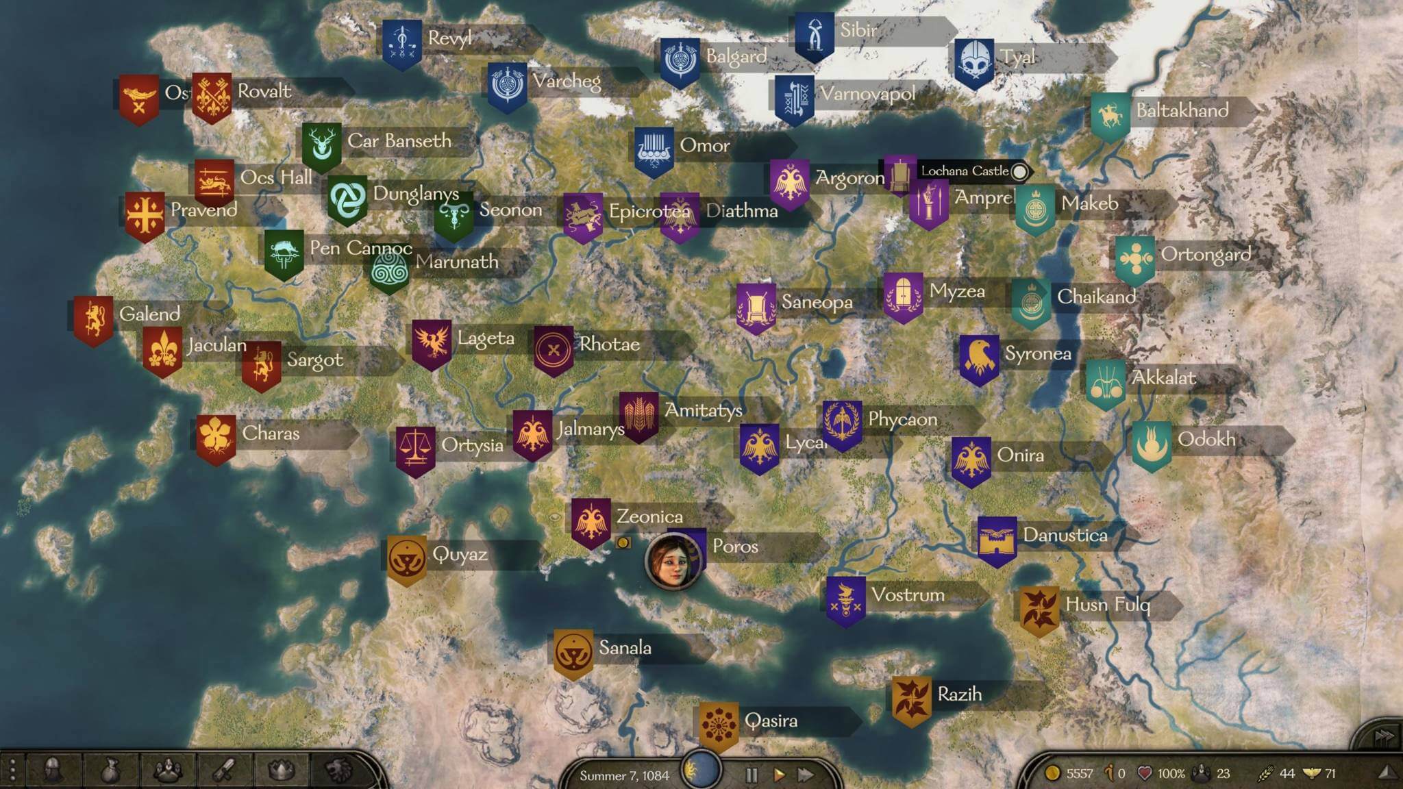
BANNERLORD:
WARBAND:

OLD MAP in DEVELOPMENT (factions overlapped; not mine):

As you can see, several differences are evident from the start:
1- The city of Sargoth migrated northwards after the fall of the Empire, and it went from being a neighbour of Velgar to being a city in the northern shore, future Nord capital.
2- Ocs Hall is obviously Uxkhal, but it's kind of in the wrong place, just like most Vlandian towns except for Praven, which is just slighly northwards from where it should be.
3- Most of the Vaegir towns are pretty much nowhere to be seen. I wouldn't mind it if the geography made it easy to see where they should be.
4- I assume the Sarranid Desert is the result of centuries of climate change drying up the sort-of-Mediterranean sea down there.This would create a death-field of salt and hight pressure, the dryest place in the world, and change forever the climate of Calradia. Maybe that explains why...
5- ...the fertile plains of Rhotae, Lageta and the heartland of the Empire are in 1257 nothing but dust and steppe, and why the rolling valleys of Poros and Amitatys are just sand and dunes. Climate change is real man!
6- I would assume most of the Battanian towns have been wiped out and a mix of Vlandians and Vaegirs took over their lands long ago, extinguishing their culture. Again, confusing geography doesn't help.
7- Cultural differenciation is also a problem. The original M&B, and then Warband, was very, very clearly inspired by a Baltic scenario. The Rhodoks' names and toponymia are very Lithuanian, and they're an elective monarchy (Poland-Lithuanian Commonwealth stand-in). The Khergits and the Vaegirs are obvious stand ins for the Golden Horde and the Russian princes, like the coalition under Alexander Nevsky. The Swadians are Germans (a mod called 1257 Edition made the comparison even more obvious by making the Swadian Kingdom into the Swadian Order and it explicitly became a stand-in for the Teutonic Order. I liked that) and the Sarranids are the only ones who don't fit the bill, but not all comparisons have to be 1:1. They're making a game, not making a point.
Of course, this parallels with the Baltics don't stand to scrutiny in Bannerlord. The ancestor of both Swadians and Rhodoks (apparently) are Feudal Normans. Ok. But then the Sturgians are a mix of Vaegirs and Nords. This makes explaining the Nords away a bit more difficult, but fine. But as you can see, the Rhodoks' clearly Lithuanian names don't translate well into their new origin as originally Vlandian territory. It's like calling a town Springfield, and 8 years later telling everyone it comes from the Haudenosaunee compound phrase "Sadranegha Bra Baldi", meaning "touching the moon with the tip of my willy". And now everyone is confused because Springfield was very obviously based on, well, the English name.
Am I taking this too seriously?
Anyway, here's my best approximation, and thanks to Vesper_ for the base map:

As a last note, I'll say that probably the devs tried to have a pretty accurate map of Calradia, true to Warband, and decided to change it at some point. Probably with good reason. I'd just like to know the reasons, otherwise I'll keep obsessing about this and won't be able to get teleworking!
Well, I care. I spent a lot of time roaming Calradia, helping caravals from Uxhall to solve the grain shortages, saving Dhirim at the edge of the day, pinning down raiders with my Khergit boys, learning the backstory of those companions, trading butter in Jelkala... and I expected to see a bit more map continuity.
As far as I've seen, this was the intention with the devs, the first maps showed the map from Warband and then an eastwards expansions. I liked it, it showed the magnitude of the fall of the Calradic Empire, that MOST of it was left in ruins in the hands of barbarians hordes like the Khergits, who occupy the western-most cities.
But several years later, the two maps don't resemble each other much. Take a look:
BANNERLORD:
WARBAND:
OLD MAP in DEVELOPMENT (factions overlapped; not mine):
As you can see, several differences are evident from the start:
1- The city of Sargoth migrated northwards after the fall of the Empire, and it went from being a neighbour of Velgar to being a city in the northern shore, future Nord capital.
2- Ocs Hall is obviously Uxkhal, but it's kind of in the wrong place, just like most Vlandian towns except for Praven, which is just slighly northwards from where it should be.
3- Most of the Vaegir towns are pretty much nowhere to be seen. I wouldn't mind it if the geography made it easy to see where they should be.
4- I assume the Sarranid Desert is the result of centuries of climate change drying up the sort-of-Mediterranean sea down there.This would create a death-field of salt and hight pressure, the dryest place in the world, and change forever the climate of Calradia. Maybe that explains why...
5- ...the fertile plains of Rhotae, Lageta and the heartland of the Empire are in 1257 nothing but dust and steppe, and why the rolling valleys of Poros and Amitatys are just sand and dunes. Climate change is real man!
6- I would assume most of the Battanian towns have been wiped out and a mix of Vlandians and Vaegirs took over their lands long ago, extinguishing their culture. Again, confusing geography doesn't help.
7- Cultural differenciation is also a problem. The original M&B, and then Warband, was very, very clearly inspired by a Baltic scenario. The Rhodoks' names and toponymia are very Lithuanian, and they're an elective monarchy (Poland-Lithuanian Commonwealth stand-in). The Khergits and the Vaegirs are obvious stand ins for the Golden Horde and the Russian princes, like the coalition under Alexander Nevsky. The Swadians are Germans (a mod called 1257 Edition made the comparison even more obvious by making the Swadian Kingdom into the Swadian Order and it explicitly became a stand-in for the Teutonic Order. I liked that) and the Sarranids are the only ones who don't fit the bill, but not all comparisons have to be 1:1. They're making a game, not making a point.
Of course, this parallels with the Baltics don't stand to scrutiny in Bannerlord. The ancestor of both Swadians and Rhodoks (apparently) are Feudal Normans. Ok. But then the Sturgians are a mix of Vaegirs and Nords. This makes explaining the Nords away a bit more difficult, but fine. But as you can see, the Rhodoks' clearly Lithuanian names don't translate well into their new origin as originally Vlandian territory. It's like calling a town Springfield, and 8 years later telling everyone it comes from the Haudenosaunee compound phrase "Sadranegha Bra Baldi", meaning "touching the moon with the tip of my willy". And now everyone is confused because Springfield was very obviously based on, well, the English name.
Am I taking this too seriously?
Anyway, here's my best approximation, and thanks to Vesper_ for the base map:
As a last note, I'll say that probably the devs tried to have a pretty accurate map of Calradia, true to Warband, and decided to change it at some point. Probably with good reason. I'd just like to know the reasons, otherwise I'll keep obsessing about this and won't be able to get teleworking!