


- Home
- Forums
- Mount & Blade: Warband
- The Forge - Mod Development
- The Caravanserai - Released Mods
- Warband
- Vikingr [M]
You are using an out of date browser. It may not display this or other websites correctly.
You should upgrade or use an alternative browser.
You should upgrade or use an alternative browser.
Territory Wars
- Thread starter Helge
- Start date
Users who are viewing this thread
Total: 2 (members: 0, guests: 2)

Moeckerkalfie
I would really rather recommend using historical examples, although you got quite a nice earth wall the map seems too small for bigger clan battles, and there appears to be only one direction to attack from, too. The map border is very close to the edge of the fortress as well, so there could be some problems with it...
And are you actually member of a clan yourself yet?
And are you actually member of a clan yourself yet?


Trelleborg:


not easy to do this one....
Castle Dore in Cornwall:

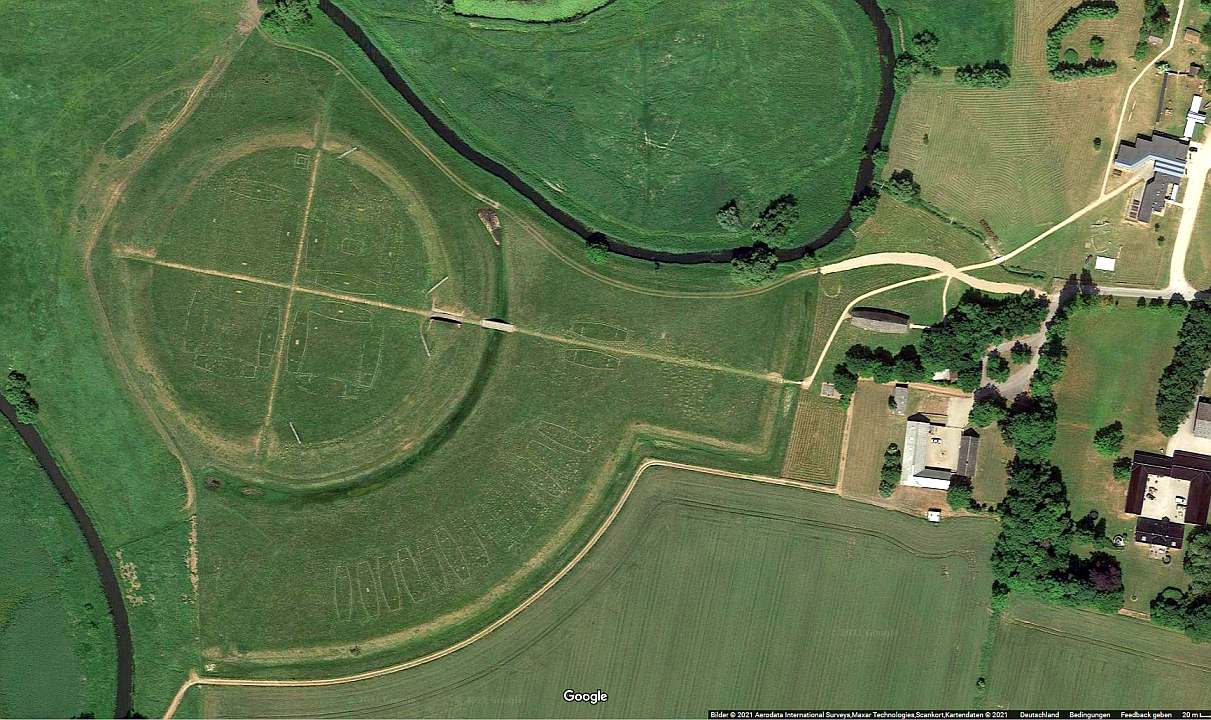
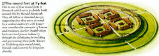
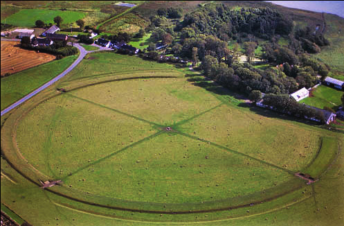
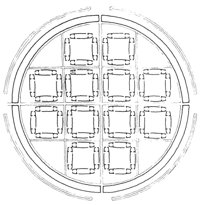
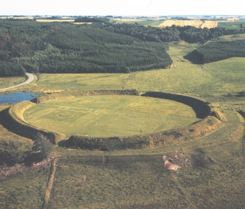
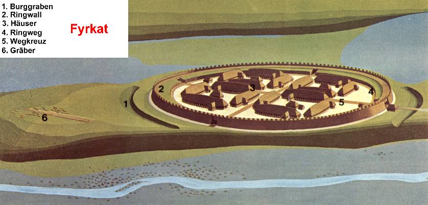
The fortress of Fyrkat in Denmark:


Aggersborg:

Fyrkat Port:
Montségur (1204):


Birka:


Birka (Garnison Castle):

King Canute's Viking Fortress:

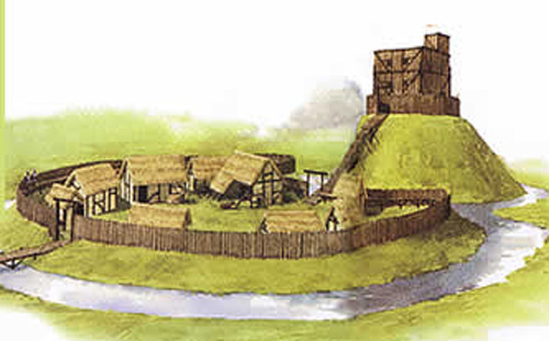
Anglo Saxon fortress:
Pilsbury Castle, Derbyshire:

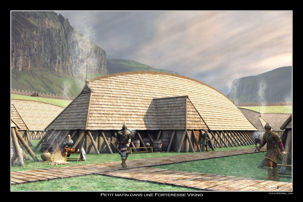
Im not good at Normas fortress but i finck it musst be like this

not easy to do this one....
Castle Dore in Cornwall:
The fortress of Fyrkat in Denmark:
Aggersborg:
Fyrkat Port:
Montségur (1204):
Birka:
Birka (Garnison Castle):
King Canute's Viking Fortress:
Anglo Saxon fortress:
Pilsbury Castle, Derbyshire:
Im not good at Normas fortress but i finck it musst be like this
Moeckerkalfie
Very good sources!
Maybe we could make a list of well-documented places and prepare material for each one. But we definitely need more contributors for something of larger scale...
Maybe we could make a list of well-documented places and prepare material for each one. But we definitely need more contributors for something of larger scale...
Thx 
We could do it like this:
Round fortresses are for Norway.Sweden, Dane.
Fortresses like Birka (Garnison Castle) are for Russ Part.
So it comes easy then.
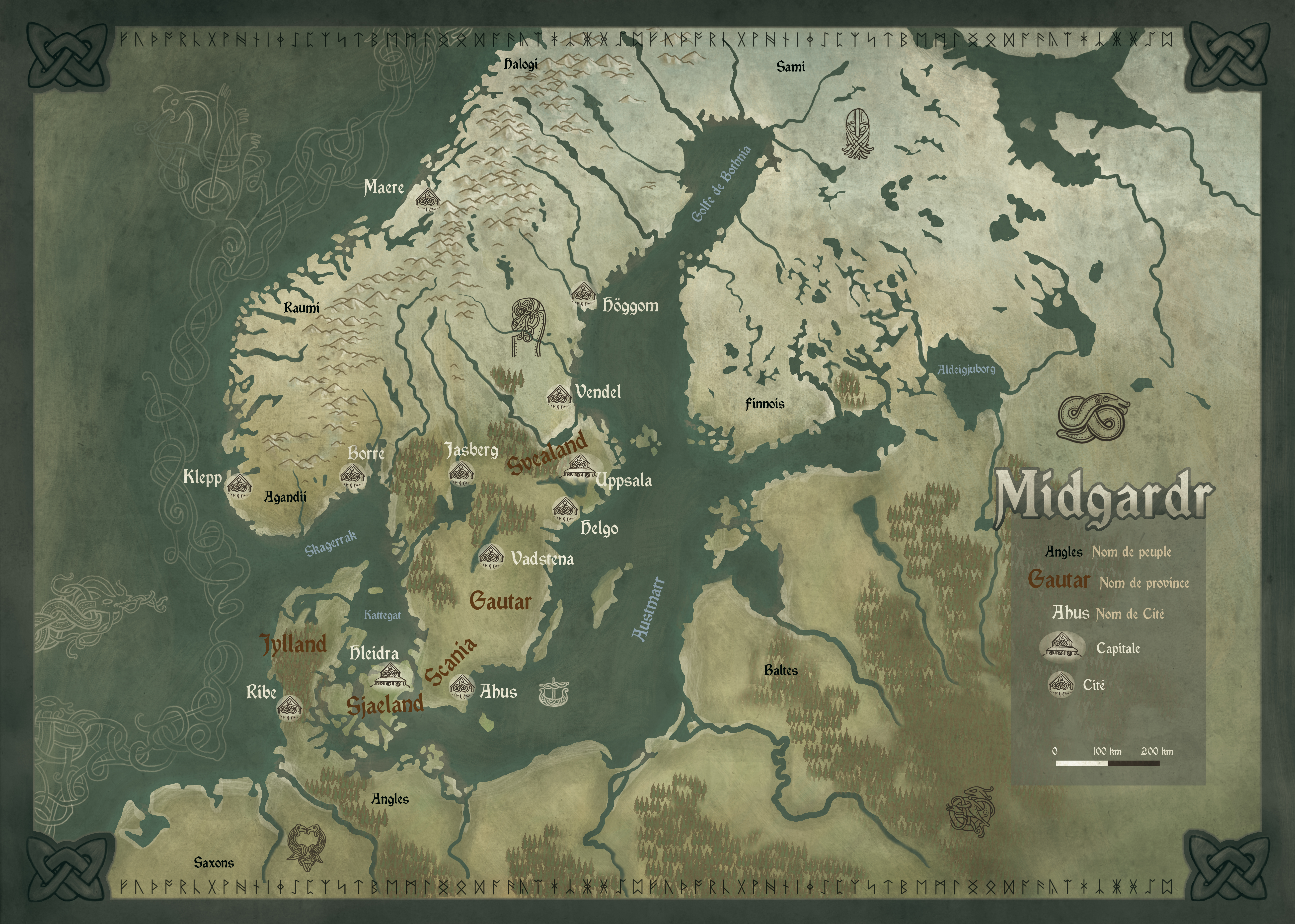
But the most important thing is! We need mane Map. Like this one but whith England ,Scotland and Iceland also.
And i cann not do this realy (( i have try it but i cann not.
PS: we cann work as a team: you make some map and if have no power to go on you schow me that map and i work on it and then i give it to you for some last things to add.
PSPS:
We cann not prepare material for each place in the map. Because all Clans can build Blockposts and Fortressts everywher
So:
We have Tarein Typ like:
Forrest
Forrest + River
Forrest + River + Mine
Mountains
Mountains+ River
and so on...
so we have to prepare 3 Levels of Fortres for each Typ. And Steel eawen whith realy good economy Clanns can not have mor the 2 or 3 Fortres because of upkeep cost.
Barabas put your big map in a spoiler for the greater good
We could do it like this:
Round fortresses are for Norway.Sweden, Dane.
Fortresses like Birka (Garnison Castle) are for Russ Part.
So it comes easy then.
But the most important thing is! We need mane Map. Like this one but whith England ,Scotland and Iceland also.
And i cann not do this realy (( i have try it but i cann not.
PS: we cann work as a team: you make some map and if have no power to go on you schow me that map and i work on it and then i give it to you for some last things to add.
PSPS:
We cann not prepare material for each place in the map. Because all Clans can build Blockposts and Fortressts everywher
So:
We have Tarein Typ like:
Forrest
Forrest + River
Forrest + River + Mine
Mountains
Mountains+ River
and so on...
so we have to prepare 3 Levels of Fortres for each Typ. And Steel eawen whith realy good economy Clanns can not have mor the 2 or 3 Fortres because of upkeep cost.
Barabas put your big map in a spoiler for the greater good


Raegenhere
Knight

Eiríkr Rauði said:Should have saved all of my work towards a 'Vikingr Campaign'. Alas, I deleted it all long ago.
Helge, I think it would be absolutely worth it to have a close look at the thread for Eirikurs campaign project (turanien is his old forum account)
I realize the project is different from this one in many aspects, but still there is lots of very good work in here, as well as valuable input by community members.
Sadly the images are all gone, but a draft of the ruleset is still online.
(apparently it needs a google account to view, i could upload it elsewhere if needed (if Eirikur doesn't object))
My advice/opinion on campaigns an similar stuff (is metagame the appropriate term?) :
it's better to keep things simple and basic at start. Too much complexity equals greater potential for bad balancing, which leads to frustration, which is deadly in the early phase. More complex features can always be added if the basic stuff works smoothly.
(I recall writing something similar is Eirikurs thread
)Thx you Raegenhere. The most important thing for me ther can be the mane map but i didnt find it ((
But INF. ther can help also. So thx you for thet.
So now i know how to build some "Viking" Fortres)


Big Map. Steel needs more Worck to be good for Bettle.Mach Places to have hold or fight. (you cann go around if you find the way)
And how to do so thet Atack-Team cann have a Ship also ? (like in the Raid battles)
But INF. ther can help also. So thx you for thet.
So now i know how to build some "Viking" Fortres
)
Big Map. Steel needs more Worck to be good for Bettle.Mach Places to have hold or fight. (you cann go around if you find the way
)And how to do so thet Atack-Team cann have a Ship also ? (like in the Raid battles)

Raegenhere said:Eiríkr Rauði said:Should have saved all of my work towards a 'Vikingr Campaign'. Alas, I deleted it all long ago.
Helge, I think it would be absolutely worth it to have a close look at the thread for Eirikurs campaign project (turanien is his old forum account)
I realize the project is different from this one in many aspects, but still there is lots of very good work in here, as well as valuable input by community members.
Sadly the images are all gone, but a draft of the ruleset is still online.
(apparently it needs a google account to view, i could upload it elsewhere if needed (if Eirikur doesn't object))
My advice/opinion on campaigns an similar stuff (is metagame the appropriate term?) :
it's better to keep things simple and basic at start. Too much complexity equals greater potential for bad balancing, which leads to frustration, which is deadly in the early phase. More complex features can always be added if the basic stuff works smoothly.
(I recall writing something similar is Eirikurs thread
Go for it.


Éadríc's map is much more in line with that of my original map (Damn! I'm sure I had a back-up somewhere) and would suit Vikingr to a much finer degree. I'd even go so far as keeping the map in brown and white tones, sepia - if you will. I had a mammoth ****-ton of research done into counties, boundaries and such things for England - the online Domesday book is a huge help, especially if you are willing to trawl through names.
Éadric
Knight at Arms

I do hope you find your own map again, Eiríkr!
As for the extent of the area shown on the map, I would suggest the following, but without everything east of the tenth degree of longitude:
So the map would include Ireland, Britain, Norway, Denmark, Frisia and Normandy (and of course implicitly the Kingdom of France and Holy Roman Empire), but not Sweden.
Moeckerkalfie
Ah you are all so eager for a large-scale map.. I really appreciate Helges effort, and I think for now we should not even go beyond the british islands. We can always increase the scale if things go very well. But since any battles we can recreate would only be small scale anyway I would rather aim to keep things in a rather small region for now. And one that is quite well documented is the south-east of england, around the Sussex and Kent area.
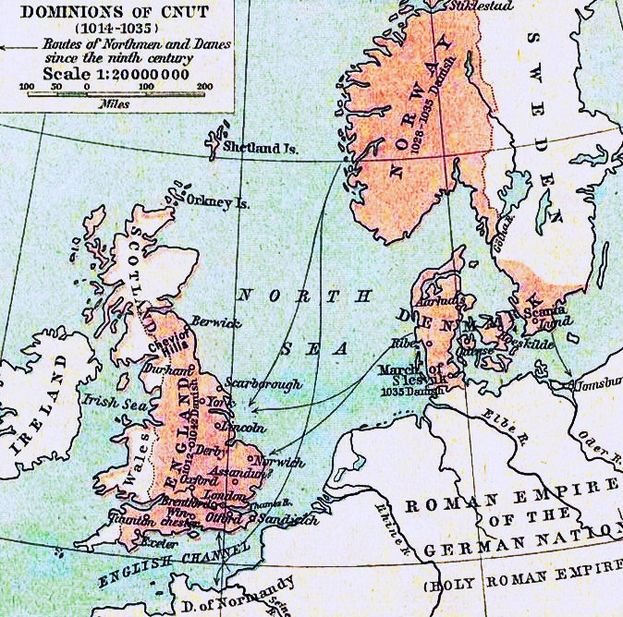
We even have this map (which portrays a later stage though) which shows the most important places at the time shortly after the norman conquest:

If we just take every of the more important places we could set up quite a bit of connected terrain already. Many of the places named here can be investigated quite succesfully, and if you think about it we already have three maps of these, namely Romenel (old romney, Eorpeburnan, which supposedly was a burgh roughly between Hawkhurst and Headcorn, and Essetesford, which is of course Ashford and was played in the event last weekend.
For Canterbury, Rye, Wye and Appledore there are sources too, as well as for Great Chart (near Ashford) and Dover. With the setting of our last event Canterbury could be pretty much the final siege of an entire campaign, and we even have sources of the walls structure safely on my harddrive.
I think a small-scale campaign like this would feel much more "alive" than having a king of norway cross the sea with four rather confused allies, landing at an undefended coast until finally defeating the two-man strong english army in a pitched battle and claiming a randomly put together London with three houses and a shed inhabited by three cats for himself.
Now the next step for this would be gathering sources for each place, pinpointing them on a map, and asking for mappers to get started on them. Each could have a set of filtered sources and maybe an overview map. I know how much effort it is to do both, so if we split it more people can help, and it will be more easy for people.
To me this seems far more likely to succeed than any more large-scale plans, but still your work is not in vain, Helge, but you could simply try to "zoom in" on this south-eastern part and maybe draw a more neat version of this cinque port map I have further upwards in my post.
But with this post I don't want to dictate you this course, but rather recommend this way, and I can just hope most of you agree with it, with all the advantages it brings.
We even have this map (which portrays a later stage though) which shows the most important places at the time shortly after the norman conquest:
If we just take every of the more important places we could set up quite a bit of connected terrain already. Many of the places named here can be investigated quite succesfully, and if you think about it we already have three maps of these, namely Romenel (old romney, Eorpeburnan, which supposedly was a burgh roughly between Hawkhurst and Headcorn, and Essetesford, which is of course Ashford and was played in the event last weekend.
For Canterbury, Rye, Wye and Appledore there are sources too, as well as for Great Chart (near Ashford) and Dover. With the setting of our last event Canterbury could be pretty much the final siege of an entire campaign, and we even have sources of the walls structure safely on my harddrive.
I think a small-scale campaign like this would feel much more "alive" than having a king of norway cross the sea with four rather confused allies, landing at an undefended coast until finally defeating the two-man strong english army in a pitched battle and claiming a randomly put together London with three houses and a shed inhabited by three cats for himself.
Now the next step for this would be gathering sources for each place, pinpointing them on a map, and asking for mappers to get started on them. Each could have a set of filtered sources and maybe an overview map. I know how much effort it is to do both, so if we split it more people can help, and it will be more easy for people.
To me this seems far more likely to succeed than any more large-scale plans, but still your work is not in vain, Helge, but you could simply try to "zoom in" on this south-eastern part and maybe draw a more neat version of this cinque port map I have further upwards in my post.
But with this post I don't want to dictate you this course, but rather recommend this way, and I can just hope most of you agree with it, with all the advantages it brings.
Éadric
Knight at Arms
Helge,
If you have Photoshop:
[list type=decimal]
[*]Click the sea with the Magic Wand Tool
[*]Right click on your selection and in the pop up menu click Select Inverse
[*]Go to the main menu: Select > Modify > Expand... and set it to 2 pixels
[*]Go to the main menu: Edit > Stroke... and set it to 1 pixel (black) - now you have an outer coast line
[*]Repeat steps 3 and 4, but set the expansion to 1 pixel extra each time
[/list]
Make sure you start your image with a high resolution.
I don't know exactly how to make the outer coast rounder, less straightish. I'm sure more experienced graphic artists have a solution for that.
Similar threads
- Replies
- 21
- Views
- 863