Need More Info Wrong map icons for villages

Users who are viewing this thread

csk1d

Recruit
c89d6d5a8e57c7a436e82df01954f2d469fcd258.png

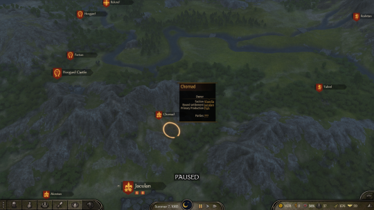
Similar to this village, there are a lot of villages that has a mismatch between primary production and their map icons, I will list all the villages with mismatch below:

Vlandia:
Cannac
Remental
Deriat
Horsger
Oritan
Fregian
Rulund
Talivel
Chornad
Arromanc

Battania:
Mag Arba
Llanoc Hen
Morihig
Pendraic
Glintor
Geunat Nal
Flintolg
Fenon Tryn

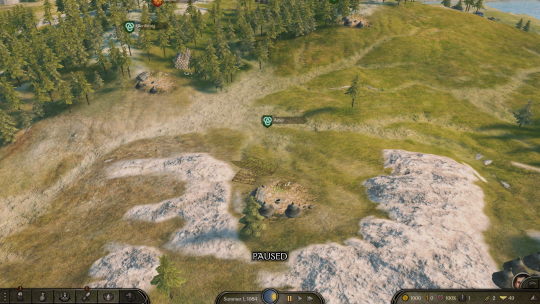
The following villages are villages that correctly shown a field, but no crops on it:

Example:
6ce6bfe14e5cf2a75a22ab2775b932c9045aa7db.png

Aster
Lindorn
Dalmengus
Inveth
Cantrec
Rhemtoil
Seordas


Sturgia:
Zhemyan
Mazhadan
Forin
Agalmon
Dvorusta
Yangutum
Borchovagorka
Visibrot


Western Empire:
Garangolia
Arpotis
Gersegos


Southern Empire:
Polisia


Northern Empire:
Temhem


Aserai:
Bir Seif
Jamayeh
Abghan
Baq
Tubilis


Khuzait:
Erzenur(Also Erzenur is too far away from Erzenur castle)
Shapeshte
Mazen
Nutyuk
Mivanjan
 
Also note that there is a mismatch between Encyclopedia description and real situtation, for example:

"Arpotis sits in the valley of the Gavys, linking lake perasos to the sea. Here in the Southern Imperial frontier, date palms are cultivated."
---Encyclopedia

However, the map icon of Arpotis is grain field and it produces olives. Similarly, Oristocroys is said to be producing silk, but instead it produces fur (Also what about the raw silk?)
 
Hello, thanks for reporting this problem. Unfortunately, we were unable to respond to this thread when it was first created. We believe the issue may have been resolved since the creation of this topic. If you are currently experiencing this issue with the latest live or beta versions of the game, please update this thread so we can forward this issue to the team for investigation.
 
Back
Top Bottom