Rethinking Borders, City-/Settlement-/Castle-positions, Road-/River-/Canal-Network
-
Is real-world inspired repositioning on a large scale worth a map revision?
-
Is real-world inspired repositioning on a large scale worth a map revision?
In a previous post I suggested some small changes for authentic bridge-, settlement- and border-placements: https://forums.taleworlds.com/index...idge-settlement-and-border-placements.423071/
The discussion and the interest in this topic encouraged me to do this on a large scale.
(@Terco_Viejo, @MArdA TaleWorlds, @GG Cannon, @Old One-Eye, @Maahes, @Dannydehz)
The discussion and the interest in this topic encouraged me to do this on a large scale.
(@Terco_Viejo, @MArdA TaleWorlds, @GG Cannon, @Old One-Eye, @Maahes, @Dannydehz)
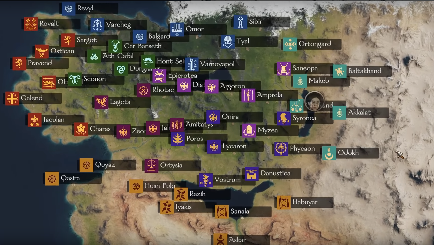
I tried to rethink Calradias border-, city-, settlement-, castle- and road-positions with inspiration from real-world maps. My restrictions for this suggestion was: sticking to the exact number and names of all Cities/Settlement/Castles and leaving them close to where they are now, but making adjustments thinking about: accessibility, protection, strategic positioning, trade, travelling, water, wind, weather, … I also tried to combine a lot of suggestions (eg. roads, cannels, strategic castle positions, feedback…) because some of them require a hand-in-hand change.
My map is only an example of what could be done:
(it can surely be better with more time and thoughts invested, but here it is: )
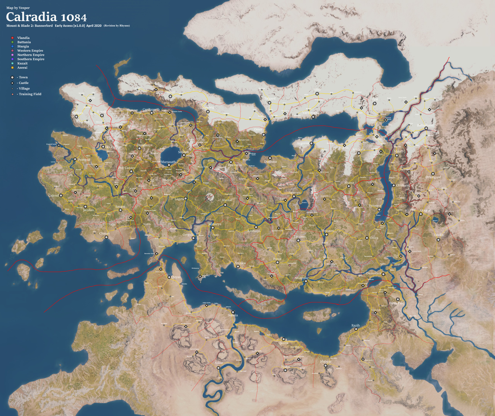
=> Link: https://66.media.tumblr.com/0c9731c.../233e830edcbabad3873cafb0f33f12c7917a5448.png
=> Original map thanks to @Vesper_ : https://forums.taleworlds.com/index.php?threads/?-map-of-calradia-1084-update-15-04-20.385748/page-10#post-9402804

… some changes are really big and it’s up for discussion if real-world inspired placements (on a large scale) are worth a map revision.
It would be too much to explain every detail of my map, but (more important) I want to explain the thoughts that led to this:
1. The Inspiration
To make this realistic, we can compare Calradia to Europe, northern Africa and western Asia, and then take inspiration from medieval maps. Here are the similarities of the cultural territories in terms of geography:
- Vlandia – Spain + Portugal (in south), France (in the centre), a bit British (on the northern Peninsular)
- Battania – Highland of Scotland, Ireland, Wales and a bit Alpine
- Sturgia –Scandinavia, a bit Britain+Falkland+Norway on the western Peninsular
- Western Empire – mostly Italy, a bit of eastern France, + the region around Gibraltar
- Aserei - sums up northern Africa and a bit of Jordan and Mesopotamia (in the east)
- Southern Empire – sums up the region between Adria, Dinaric Alps, Carpathian, Balkan, Black sea, + a bit Greece and Turkey
- Khuzait – sums up east Europe and west Asia (Ural, Caspian sea, black sea, Caucasus, …)
- Norther Empire – looks like it only features Alps and Carpathian, but stretched up to the North- and Baltic-sea (Austria, Germany, Bohemia, Poland, Hungary,…)
I also tried to find real-world excamples for some cities, thinking of the surrounding land and what the cities role could have been.
(I compared them to cities from medieval maps because big and popular cities on modern maps could have been less important in medieval times … their still might be better examples for some cities but I can only name the ones I know / or the ones I have found)
- Danustica - Istanbul (ex Constantinople)
- Razih - Beirut / Jerusalem
- Sanala - Alexandria
- Lageta - Strasbourg
- Rhotae - Milan
- Amitatys - Verona
- Jalmarys - Turin / Florenz
- Lycaron - Bologna
- Zeonica - (a lot of Italian Harbour cities would fit)
- Ortysia - Marseille / Barcelona
- Charas - Gades (Cádiz) / Lisabon
- Sargot - Avignon / Toulouse / Lyon / …
- Jaculan / Galend - Cordoba / Toledo (a lot of Spanish cities close to mountains would fit)
- Pravend - Luxembourg (Paris/Orleans if it was at the river which I would suggest for Vlandia)
- Ocs Hall - (not shure… river lake, mountain… I searched between France and Swiss)
- Ostican - Dover
- Car Banseth - (could be comparable to Edinburgh if it was a harbour city further north)
- Dunglanys - York (if it wasn’t on top of a mountain)
- Pen Cannoc - Stirling (“Gateway to the Highlands“)
- Omor - Stockholm
- Varnovapol - Bergen
- Onira - Budapest / Prague
- Saneopa - Vienna
- Phycaon - Nurnberg
- Argoron - Hamburg / Bremen
- Diathma - Brugge
- Epicrotea - Salzburg / Geneva
- Quyaz - Tunis / Tangier
- Baltakhand - Novgorod
- Makeb - Kiev
- Syronea - Nessebar / Sozopol / Varnas …
- Chaikand - Baku
- Akkalat - Tiflis
- Husn Fulq - Homs / Aleppo
- Vostrum - Athen
For roads/canals I took inspiration from maps showing the early roman network (http://orbis.stanford.edu/ ... thanks Terco) and some maps from later medieval periods to see how the networks continued to north and east.
2. Main Borders
I tried to redraw the cultural borders keeping the original locations (with minimal changes) but using as many natural borders as possible (ridges of mountains and hills, rivers, (possible) streams, dense woods…). For the split empire I also chose the obvious mountains etc. I also looked at the borders between Austria and Hungary and would say it is even plausible for the empire to draw arbitrary lines through the land (at some points). (I know that the empire is Roman inspired, but Austro-Hungary is an example for a fallen empire which’s borders remained and can be seen close up on modern maps.)
- I gave the north eastern corner to the Sturgians (because in most games they get overwhelmed by the Khuzait very fast)
- I swapped the Counties Nevyansk and Uthelaim for better connections (I think not having this enclave also helps Sturgia.)
- I also gave the county of Caleus to Battania so they own the whole northern coast (this was an enclave for Vlandia, it doesn’t hurt if they don’t have it, most of the times Vlandia expands fast anyway)
- I swapped Gaos, Thorios and Sesteim between the empires for better connections/divisions
3. Castles
Castles are most likely there, where natural borders leave a gap (allowing entrance to the land). Castles have to block this gaps, they need a good view and a defensive position (on a hill, on a cliff, next to a river with a moat, …).
I adjusted a lot of castle positions to where I think they have a good strategic position (also considering naval movement).
4. Rivers and Canals
I assume that there are far more Rivers and streams than we see on the map because somehow every city and settlement needs water-access (wells and aqueducts also work for some of them). So the rivers we see are just the biggest. Some rivers are very steep and icy and make good borders, but most rivers would have been very important for transport and trading. At some points people surely would have tried to connect narrow gaps with canals as proposed in the map.
- Canal north to Lageta
- Canal through Rhotea
- Canal through Saneopa
- River prepairation north of Phycaon
- Canal between Gororys and Avalyps
- Canals around Danustica (maybe even through Danustica to make this city really comparable to Istambul)
5. Cities
Cities are the oldest settlements and crossing points for trade routes. Accessibility was essential for the city’s development. Inspired by the real-world examples for the cities I adjusted their position for better accessibility. (preferring rivers and coasts, putting Harbour cities at river mouths where possible, putting cities into valleys instead on top of mountains…)
I was really harsh with Battania here because I think the easier accessible settlements in the valleys would have developed into bigger cities than the ones on the cliffs/mountains.
6. Roads
Humans and animals would choose the way of least resistance. A short way, but still keeping height difference low, following rivers and valleys, avoiding dense vegetation or wetlands … In the desert they would go where they have water and they would prefer to walk in shadows and slipstreams of mountains.
First, I got rid of all bridges, because the roads need to come first. Then I tried to connect harbours, rivers, valleys as shown on the map. The road layout was initially designed for the places that are in game, but in a second step I adjusted the positions + roads to more attractive settlement-locations
7. Settlements
Settlements would probably form close to the resources but on the roads (for trade). If they have formed “offroad”, they could have changed the way caravans and travellers go (=> a new road closer/through the settlement could have established). Settlements also need protection: castles / natural protection.
Their position was adjusted considering protection, resources, traffic and preferring rivers, valleys and coasts.
8. Resources
Many suggestions point out a questionable distribution of some resources. I don’t want to go into detail here, but I think the comparison to real-world geography and places (1) gives a good idea of what we can expect to find.
(9. Wind zones)
following resources, I wanted to add one thing: I wonder why the surrounding of Drapand, Charas, Ostysia is so try and why the corner southwest of Ain Baliq is green. The “European part” of Calradia would be in a west wind zone (wet air from the ocean west to east) and the “north African part” of Calradia would be in an east wind zone (try air from the desert east to west) …
(of course this is a minimal detail … Calradia is already more realistic than most other maps *Tamriel *cough *Essos *cough …)
This are my suggestions how (most of) the discussed map changes could be made.
What do you think about it?
Are there some details you would suggest?
And ... Is repositioning on a large scale worth a map revision?
*EDIT: If you want to edit something / make further suggestions ... feel free to use the PDN (picture file with layers). And just like Vesper, i feel honored if you leave a credit for me as well


Last edited by a moderator: