

Calradic Navigation Debate
Much has been said about naval combat, if it will or will not be included in the final version or if it will be enabled as downloadable content. On the other hand, there is a question that has hardly been taken up in the debate and it is the following one:
Is the Bannerlord map really designed to use navigation effectively? For maritime navigation (commercial - military), no doubt; only that if we stick to the current map, the potentially initial seafaring factions can only be Sturgia, Vlandia and Aserai as they have coastal cities, it is obvious. In the Warband lore we were told then about the imperial galleys, however in the current map the empire does not have coastal cities; therefore the power of the imperial navy is currently null. So why can't the other factions eventually become a naval power? Where would the option of river navigation fit into the current map if we decided to establish trade routes and naval military development through river-sea-land connections? That way, it doesn't fit.
And I say it doesn't fit because we have a problem, which is the nature of the current rivers themselves.
A little context:
Currently in Calradia we only have land travel to move armies or to develop economic activities through the use of trade routes. If we focus strictly on the rivers, we can affirm that they are currently a simple decorative adornment and should become instruments of border delineation and a way of commercial expansion if we really want to apply a naval system properly.
Therefore, if we want to apply a naval system properly, we must face a series of problems that arise with the current map:

Rivers are not border elements or delimiting elements of movement as they allow free passage through a series of points or areas such as bridges, rocks, and so on. Obviously they are not navigable. If rivers were really an obstacle and established a border landmark, natural points of strangulation and shock would be created that we could add to the existing ones. Because according to Taleworlds:
“The topography of the map is not entirely consistent with Warband, in fact Bannerlord's map is somewhat more mountainous. The effect of this is an increase in the number of choke points. It will be hard to avoid conflict, for instance, when traversing narrow passes through mountain ranges that may be riddled with ambush spots or enemy patrols. Tactically, the map offers many more options for controlling areas that serve as trade routes. Battles are often fought in the game to contest key choke points with the goal of securing passage for trade caravans and other parties. As a player, it is important to consider what kind of warfare you are likely to end up in, before sacrificing relations with a faction.”
When establishing a fluvial navigation system we must provide the Calradic rivers with a real nature in width and draught so that in this way the military and commercial expansion is developed in a natural way. Taking a look at the reality in which Bannerlord is inspired, we find a series of rivers that must be highlighted due to their high commercial and geographical interest.

The Roman Fluvial Navy
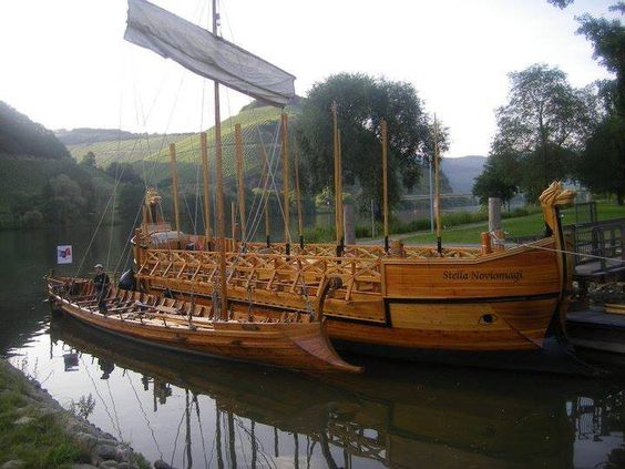
When we think of an imperial army, our brain evokes images of large fleets sailing the ocean, although this was not always the case. In those areas in which the Roman military dominion was not very strong and which had navigable rivers, fluvial armies divided into Classis were established.
The Classis Germanica was the largest Roman fluvial navy and had the task of supervising the Rhine, its navigable tributaries and the area of the North Sea around the delta formed by the river at its estuary, in order to maintain fluid traffic and protect trade on the Rhine.
On the Danube there was not one classis, but two: the Classis Moesica and the Classis Pannonica. The Classis Pannonica was a hundred percent fluvial navy. It patrolled (and protected) the Danube from Castra Regina (present-day Regensburg) to the Iron Gates. In this final stretch its most important base was in Singidunum (modern Belgrade). Classis Moesica was in charge of patrolling the lower part of the Danube from the Iron Gates to the Black Sea, including its northwest coast and even the Crimean peninsula.
The Galias also had their own fluvial navy patrolling the rivers of the Gaulish provinces and even some of their lakes. The most noteworthy were: the Classis Fluminis Rhodani, in the Rhone, the Classis Anderatianorum, in the Seine and the Oise and the Classis Araricae, in the Saona.
Viking Incursions

They are sounded the incursions going up rivers, the most outstanding and known is the Siege of Paris (885-886) where the Vikings advanced by the Seine arriving in Paris on November 24 with 700 ships.

In the Middle Ages, the commercial route of the Volga connected Northern Europe and Northwest Russia with the Caspian Sea. The Rus used this route to trade with Muslim countries on the southern shores of the Caspian Sea, sometimes going even further, such as to Baghdad. The route ran concurrently with the trade route of the river Dnieper, better known as the trade route from the Varangians to the Greeks, and lost its importance by the eleventh century. In addition, the most important river networks were those of the Po River, the Rhône, the Flemish river network, the Rhine and the Danube.

On December 31, 406, in the West of the Roman Empire; the warriors of different " barbarian " peoples fundamentally referred to the Vandals, Alans and Suevi cross the famous river Rhine, frozen by the harsh winter, which was the natural boundary and border of the Roman Empire and the Germanic tribes, starting almost officially the slow and gradual invasion of Gaul.
Thanks to conceptual art we know of the existence of different types of ships within the category of "civil ship". However, if we want to dominate both the seas and the rivers we need to develop military ships. Following the artistic line of the illustration of Oğuz Tunceli, here you have two military ships that follow the line of imperial design; the Byzantine liburna and Dromon. These ships were of remarkable size, 30-50 meters long and 5-7 meters wide so they could accommodate between 150 and 200 men among rowers, soldiers and sailors.

Considering the dimensions of the naval battle scenes we have in Viking Conquest and that Bannerlord bets on a remarkable increase in the number of bots on scene compared to Warband; we would need wide river scenes like those mentioned above to simulate minimally realistic conditions for a pleasant playable experience.
Fluvial scenes no smaller in size than those shown in this video:
We also know that the Calradia map in Bannerlord, will suffer the meteorological effects of the passing seasons. It is important to highlight the winter season where apparently in this video the rivers and lakes freeze.
This climatic factor is decisive as it provides a specific period of activity for the free passage (see Climatic backgrounds) and at the same time another period of inactivity or blockade of the same fluvial routes (commercial - military). Therefore, in the northern areas of Calradia there will be penalizing and enabling conditions at the same time and shock points.

With these arguments the space for debate is opened.